High-Resolution German – Saxony DTM Models – Now in windPRO
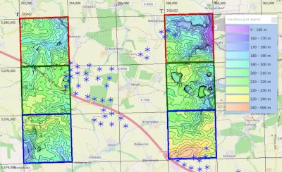
A high-resolution digital terrain model (DTM) for the German Bundesland of Saxony (Sachsen) is now released as a part of the online data services for users of windPRO 3.3. This dataset originates from detailed annual laser-scans of Saxony – years 2008-2019. Here, the native DTM grid resolution is at 1m or 2m. For such DTM data to be workable for the larger domains analysed in wind energy applications, EMD has resampled the highest resolution data at a minimal loss of accuracy to a 5m grid. In addition to the 5m resolution data – a 20m resolution dataset is also released. Read more at the documentation page for the Saxony DTM-model.
The picture shows wind turbines south of Wermsdorf, Saxony.
Elevation data: EMD/windPRO elevation model. Based on data from GeoSN, dl-de/by-2-0 Background map: © OpenStreetMap contributors
Read more:
Saxony Elevation Model
Online Datasets in windPRO