New and more precise global DEM in windPRO: AW3D30
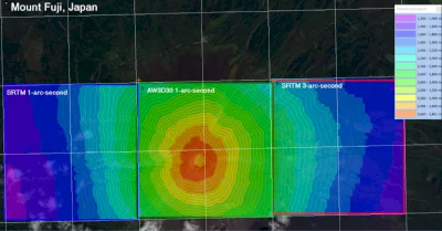
The “ALOS World 3D 30 m mesh (AW3D30)” dataset is a recent digital surface model (DSM) with global coverage. It is produced by JAXA – Japan’s Aerospace Exploration Agency. Now users of windPRO have direct access to the data in its 30m resolution version – along with its data-quality mask. AW3D30 was generated from data obtained from the Panchromatic Remote-sensing Instrument for Stereo Mapping (PRISM) – an instrument that was carried onboard the Japanese Advanced Land Observing Satellite (ALOS).
The AW3D30 dataset is expected to be more precise than SRTM1 – however is still not completely without issues. At this time, we see the dataset as a supplement to SRTM1 – and as a valuable source to mitigate uncertainties related to the digital elevation modelling (DEM) – rather than a complete SRTM replacement. We encourage you to test it at your sites – and to learn more of AW3D30 at the windPRO wiki: