Now in windPRO – Near-Global Forest Canopy Heights
The ”Near-Global Forest Canopy Heights GLAD” dataset is developed from a fusion of GEDI lidar data (Global Ecosystem Dynamics Investigation Lidar) and Landsat imagery data.
It has a near-global spatial coverage ranging from latitudes S52.0 to N52.0, and it reflects the 95% relative height of the canopy with a 25m ground area footprint. The GEDI instrument is an experiment from the International Space Station: It maps the Earth´s forest and topography using a high-resolution laser. This fusion dataset is developed by the Global Land Analysis and Discovery laboratory (GLAD) at the University of Maryland, USA.
If you are developing wind farms at forested sites, you can use this new forest height dataset as input for the dedicated forest models in recent versions of windPRO: (1) The displacement height calculator and (2) the Objective Roughness Approach (ORA).
The ”Near-Global Forest Canopy Heights GLAD” dataset has already been released and is available from the windPRO online-data services.
More information about the dataset is available online here
Missing data in windPRO?
Feel free to suggest other datasets to be included in windPRO by completing our online form
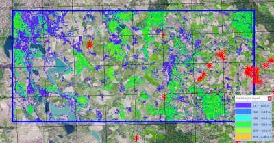
Image: ”Near-Global Forest Canopy Heights GLAD” – 30m grid resolution – Site South-East of Leipzig, Germany.
Data source: Global forest height data from the Global Land Analysis and Discovery Laboratory.