Saxony-Anhalt High Quality DTMs – 5m and 20m – Now in windPRO
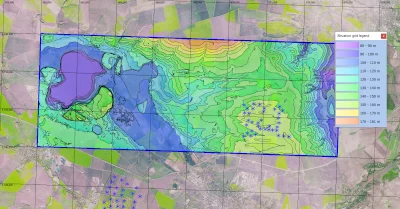
Two high-quality digital terrain models (DTM’s) in 5m and 20m resolution covering the German state of Saxony-Anhalt have now been added to the online-services of windPRO 3.4. These elevation models are derived from a higher resolution model (2m grid-resolution), recently released from the Landesamtes für Vermessung und Geoinformation Sachsen-Anhalt (LVermGeo). Source data originates from years 2015-2018.
Let us know:
The windPRO team is committed to providing you the best of land-surface and climate datasets: Let us know if there is a dataset with an open license you would like to see in windPRO – please use our form here.
Image: Saxony-Anhalt Elevation Model: DGM 5m and wind farms at a location near Concordiasee to the South-West of Magdeburg. Source: EMD/windPRO elevation model based on data from © GeoBasis-DE / LVermGeo LSA. Background image: windPRO European VHR Satellite Imagery – 2.5m by EMD International A/S (Contains modified Copernicus data).