SOLAR PV
The SOLAR PV Module makes it easy to combine wind and solar power projects. Auto-fill with panels and calculate the annual energy production including shadow losses. Enjoy seamless integration with other data and visualization modules in the windPRO software suite
-
Fast design
Quickly define areas to fill with panels, and add exclusion zones for substations, roads etc. -
Save time
Use the familiar windPRO features to design, calculate, and visualize solar PV projects. -
Free Heliosat (SARAH) Solar Data
Download 20y long-term solar irradiation data for AEP calculation. -
3D Shading losses
Quantify the losses from wind turbines, topography, obstacles and other solar panels -
Bankable AEP calculations
Use measured and/or modelled climate data to create bankable AEP calculations. Generate time series, shape files and reports -
Photomontage integration
Create photo-realistic renderings of both panels and turbines in PHOTOMONTAGE

Fast Design
Auto-fill areas with solar panels
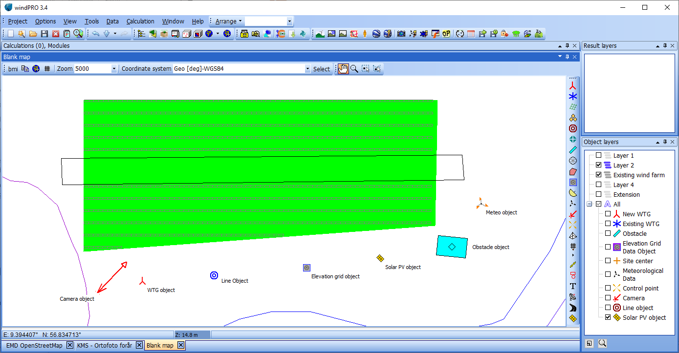
Easily draw up an area to be filled with solar PV panels. The layout of the panels is automatically adjusted according to the geometry of the individual panels and rack/table size, which can be modified on-the-fly using the interactive solar control panel.

Exclusion zones
Draw exclusion zones where no solar panels may be placed. This can be used for substations, maintenance buildings, access roads, buffer zones etc.

Multiple areas
Different slopes and curvatures in the terrain call for individual solar panel layout. With the Solar PV module you can define individual characteristics for each area, such as spacing between panel rows, azimuth, tilt angle and panel sizes.


Save time
With the Solar PV module, you can quickly design a solar farm layout and calculate the AEP using the same tools as for wind projects, utilizing the same elevation data, maps, turbines, obstacles, cameras etc.
The interactive view of calculation results makes the design fast and easy to review and optimize.

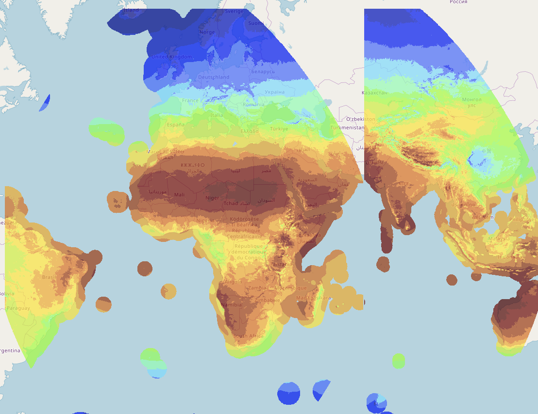
Free Heliosat (SARAH) Solar Data
When using the Solar PV module, you can download 20-year Heliosat (SARAH) Solar irradiation data (1999-2020) covering two-third’s of the globe.
Heliosat (SARAH) solar data normally require data purchase from third-party vendors but is freely available in the Solar PV module though the windPRO Online Data Service.
Image source: Heliosat (SARAH). Distribution through EMD and windPRO – EMD International A/S, 2020. This dataset uses Heliosat (SARAH) data which is being developed by EUMETSAT CM SAF (Satellite Application Facility on Climate Monitoring) – see https://www.cmsaf.eu/.

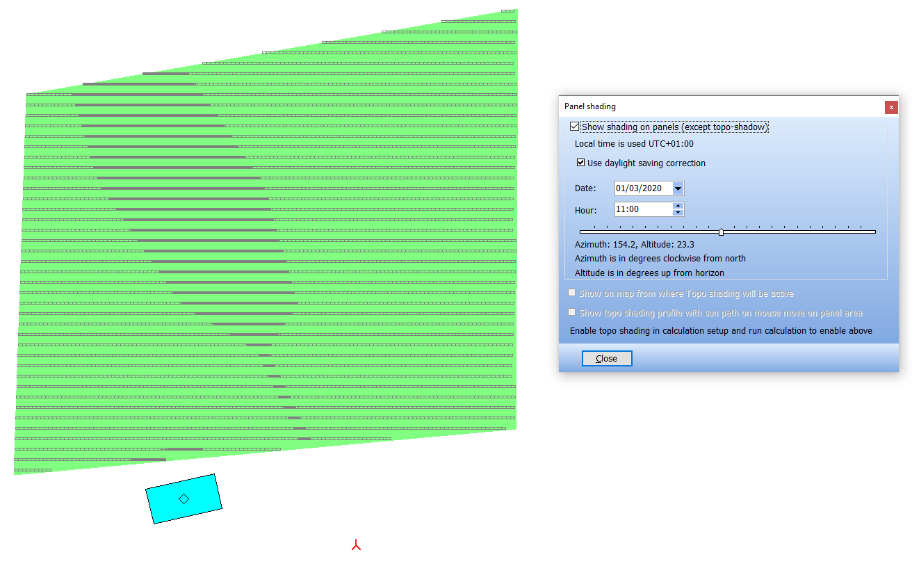
Detailed Shading Losses
When designing a solar farm, one of the major energy loss components is the shading loss. With windPROs SOLAR PV module, it is easy to model the losses of different shading objects.
Turbine blade shadow loss
Installing solar panels in a wind farm may lead to complex shadow losses due to the rotation of the turbines’ blades. Utilizing windPRO’s information about the surrounding wind farm and its production, the energy loss caused by blade shadows can be calculated, timestep by timestep.
Topographic shadow loss
Use the best terrain data available by utilizing windPRO’s many terrain handling abilities. Easily download regional, national or global terrain model datasets and immediately use them to generate a solar panel layout and accurately calculate the topographic shadow losses. With more than 20 national elevation data sets on hand you don’t have to rely on coarse resolution SRTM data.
Panel self-shading
Benefit from detailed terrain data to accurately calculate the loss of diffuse and direct radiation, caused by shading from other nearby solar panel rows. Optionally, calculate the energy loss caused by the shading from other obstacles in the vicinity.

Bankable AEP Calculations
The Solar PV module includes features for comprehensive handling of solar irradiation data, including features for long term correction of local measurements with long term measurements or model data. Import of measured and/or modelled climate data sources (except Heliosat) requires the METEO module.
When using the Meteoanalyser tool included in the METEO module users gets access to additional features for advanced solar data analysis.
The result is reliable and precise AEP calculations for PV projects according to bankable standards known from other types of renewable energy projects.

Photomontage integration
Together with the PHOTOMONTAGE module it is easy to produce high-quality realistic visualizations of the proposed PV projects in a landscape photo (normal or panoramic view) or based on Google Street View images.