Latvian Geodata Package – Now Available in windPRO
Now windPRO users developing wind farms in Latvia have easy access to a comprehensive package with very high-resolution Latvian national geodata. The data is available through the online-data services in windPRO 3.3+ and includes national elevation model (20m resolution) and forest height data (5m resolution, currently with spatial coverage of about half of Latvia). Topographic maps and orthophotos are available in different scales as dynamic zoomable maps.
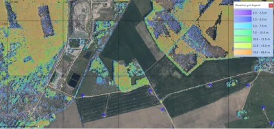
The picture shows an example of Latvian canopy height data 2013-2016 in windPRO – a wind farm at Grobina, Latvia. The new Latvian orthophotos are used as the background image.
Read more:
A full set of documentation pages on the new Latvian datasets are available on the windPRO knowledgebase:
National Elevation Model
Forest Map
Dynamic Topographic Map
Dynamic Orthophotos
Contact Us:
Feel free to reach out to the windPRO hotline for any comments or suggestions: support@emd.dk.
Data Credits:
JSC “Latvian state Forests” for canopy height data. For orthophotos © Latvian Geospatial Information Agency, 2013 – 2017.