Norwegian Elevation Models – Now Available Directly in windPRO
The national digital elevation models for Norway – released by the Norwegian ‘Kartverket’ – are now available as a part of the online data service for users of windPRO 3.2. In windPRO you can access the digital elevation model (DTM10) – as well as the digital surface model (DOM10). The data is available in a 10m grid resolution and is accessed from the ‘elevation grid object’ with data-types set to either ‘Elevation data’ or ‘Surface data’. It is also possible to download the contour line data directly from within the ‘line object’. The main part of the data is originating from detailed laser-scans of Norway.
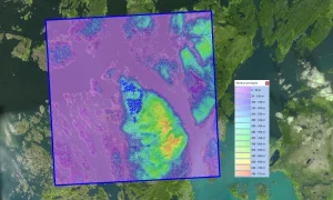
The picture shows part of the national Norwegian digital elevation model (DTM10) – seen with the 44 wind turbines at Midtfjellet wind farm site in Norway. The background image is one of the new dynamic maps in windPRO – the windPRO European Satellite Imagery in 2.5m resolution. Elevation data source: “DTM10/DOM10” by Kartverket is licensed under CC BY 4.0.
Read more here:
Norwegian Elevation Models
windPRO European Satellite Imagery